


– photo credit: firebomber68 photography – Dan Dinneen –
The Deer Zone Fire complex in rural Contra Costa County between Clayton and Brentwood had burned more than 1,450 acres by Tuesday morning, and remained at zero percent containment, a Cal Fire spokesman said.
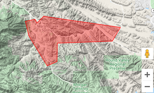
Evacuations ordered late Sunday along Marsh Creek and Morgan Territory Roads remain in effect Tuesday morning.
The evacuations were ordered at about 9:20 p.m. Sunday after what firefighters said was a “change in behavior” of the fire.
Those mandatory evacuations directly affect people who live along the length of Morgan Territory Road south to the Alameda County line and along Marsh Creek Road from Bragdon Way to Deer Valley Rd.
No structures have been damaged by these fires as of Tuesday morning, Cal Fire officials said.
A Cal Fire spokesman said Tuesday that in rural Contra Costa County, as elsewhere in the region, a combination of high temperatures, inaccessible terrain and “dangerous rate of spread” are making fighting the fires especially difficult.
anyone remember how long it took to get this under control last time?
Thank you to CalFire and all the firefighters!!
just going off topic in relation to PG&E everybody check out your daily usage.
ours says they just gave us an estimate on Aug,14th. which was very high. I think that was the outage day. anyway it has been sky high the following days. and we have kept everything at required levels per their recommendation. now as for the fire. put it out. thanks.
Just wondering why the “Deer Zones” incident was removed from the Cal Fire active fire list. https://www.fire.ca.gov/incidents/
I see that they have included it in with the other lighting fires, “SCU Lightning Complex”, so its now harder to see how much its burned or location.
From SFGate: https://www.sfgate.com/news/bayarea/article/Deer-Complex-Fires-At-1-450-Acres-0-Percent-15492701.php
NASA has a map that gives an idea of it
https://firms.modaps.eosdis.nasa.gov/map/#d:2020-08-17..2020-08-18;l:street;@-121.8,37.8,12z
My link got butchered a bit
you can just go to https://firms.modaps.eosdis.nasa.gov/map/ and find it
Great find Hmm, thanks.
As per CalFire website last nite at 830pm (which currently doesnt show this Deer Zone fire on its map anymore this morning), it was 14xx acres, so this is over 12 hours out of date, likely much higher acherage burned.
I was looking for the fire on calfire today and I found it they combined a bunch of the fires
https://www.fire.ca.gov/incidents/2020/8/18/scu-lightning-complex/
Is the area in red the burned out part. I would like to see a map of where it has burned and which way it is headed
The map shows the evacuation zone, not the burn zone.