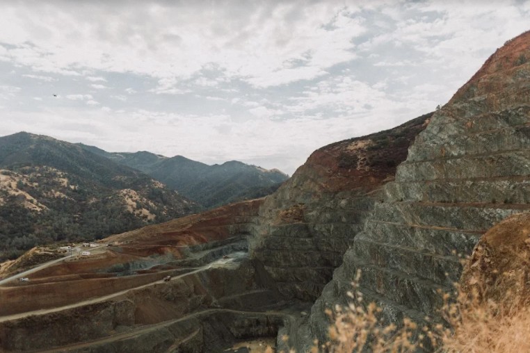
photo credit: CEMEX Clayton Quarry
CEMEX announced today that Contra Costa County has approved the company’s amended reclamation plan for the Clayton Quarry after the county’s planning commission voted 6-0 in favor of two land use permits related to the proposal.
“We are pleased the county planning commission approved an environmental blueprint for how CEMEX will transition its quarry to permanent open space when operations eventually conclude at the site,” said CEMEX USA Regional President—California Region Francisco Rivera.
The newly adopted plan does not introduce changes to production levels, hours of operation or methods of mining. Reclamation is a process that runs concurrent with operations, providing public benefits even before operations cease.
“After seven years of working with neighbors and county planners, we look forward to proceeding with a reclamation plan so that our community can enjoy all the benefits of open space for generations to come,” said Rivera.
Clayton Quarry has been in operation for more than 70 years, and over the last three decades, it has followed a reclamation plan developed by a predecessor company. The newly adopted plan complies with State reclamation standards and updates the previous plan by significantly reducing the visibility of the quarry face, and includes drainage improvements, greater habitat restoration and ensures that once mining ceases the land cannot be used for future development.
Benefits of the Amended Plan, according to CEMEX:
- Mining Footprint: Smaller mining area than previous plan, a reduction of 57 acres or by 43%.
- Improved Views: Preservation of the east rim, reducing visibility of the quarry face.
- Neighborhood Screening: A screening berm will be constructed between the existing processing plant and residential communities to the north, intended to reduce noise and dust.
- Drainage Improvements: Storm water from the quarry face will fill the quarry lake over a period of approximately 100+ years, and when combined with a controlled flow system, the new drainage system will minimize the risk of runoff.
- Revegetation: A combination of chaparral and grassland habits will be used to revegetate the quarry east rim, overburden fill areas, and at the processing plant site. Removed trees will be replaced with oak trees at a 3:1 ratio.
- Protecting Open Space: The quarry’s 440-acre site will be preserved as permanent open space, and with 100 acres being conveyed to Mount Diablo State Park in the immediate future.
The former reclamation plan anticipated 120 years of operations or until the year 2101, this revised plan envisions the life of the quarry to end around 2055.


Yeah…. and in 33 years they’ll “amend” the plan again.
Clayton will be choking on their dust forever.
Oh the rich people now are tired of the dust and looking at an eyes sore? Now they do something about it after 70yrs? FYI I believe there is a high ranking public figure that lives near the quarry is probably why things are changing now.
@Dean – which “high ranking official,” and where is his / her / it’s (but NOT their, because “their” is a plural pronoun) house?
Yeah, I’m calling you out. Put up or shut up, sir.
Yes there’re in Round hill in Clayton. It’s no secret do your searching you might find out..locals ain’t gonna tell you.
A quarry lake, wonder what naturally occurring pollution will concentrate in said lake. An will that lake size be measured in millions of gallons ? ?
Will the “lake” level be artificially controlled thru pump down?
Given the depth of the quarry, if allowed to fill unimpeded, has a study been done as to effects of immense pressure new lake would exert on surrounding land and possible effect on earthquake faults?
Little stuff, bureaucrats might not question . . .
33 years? Not soon enough.
Lake?! You mean like the Berkeley Pit in Butte, Montana? The Berkeley Pit is full of heavy metals and periodically threatens to overflow into the city of Butte, which would be seriously unhealthy to the people living there.