The California Geological Survey has issued new tsunami hazard maps for San Francisco, Santa Clara and Contra Costa counties, now updated to account for a “worst-case scenario.”
The 2021 maps, crafted by the CGS in partnership with the California Governor’s Office of Emergency Services, replace 2009 versions with new estimates covering larger areas that may need to be evacuated in the event of a tsunami.
According to Steve Bohlen, acting state geologist of California and head of the CGS, the heightened level of precaution was inspired by the 2011 Tohoku-Oki earthquake and tsunami.
“Japan utilized data from several hundred years of tsunami records in its planning, which seemed perfectly reasonable,” Bohlen said in a statement. “Then it was impacted by a once-a-millennium tsunami.”
The CGS’s “worst-case scenario” for the Bay Area would be a 9.3-magnitude earthquake in the Aleutian Islands off the west coast of Alaska. A tsunami caused by such an earthquake, the CGS said, would reach the Bay Area within five hours, leaving little time for an evacuation warning to be issued and residents to safely evacuate.
In 1964, a 9.2 earthquake in Alaska caused a tsunami to reach Crescent City in four hours, killing 12 and destroying much of the town’s business district.
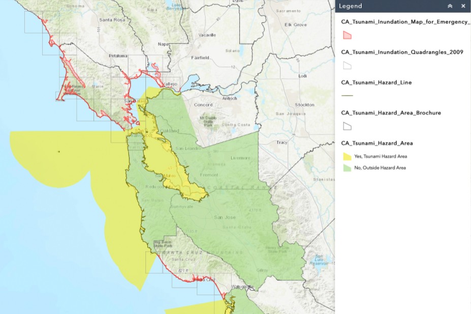
Using the Aleutian Islands scenario, along with other sources, the CGS developed new tsunami hazard maps to inform residents and emergency response planners what areas may need to be evacuated and how far inland they would have to move.
The most significant increase in the tsunami hazard area, according to the CGS, is low elevation land in San Francisco’s North Beach and downtown Market Street, as well as residential and commercial area around the Port of Richmond.
The new maps will help inform the State Hazard Mitigation Plan so state agencies, local and tribal governments can prepare to respond to potential tsunamis. The maps may also help inform climate change response, the CGS said, as the same low-level areas that are vulnerable to flooding during a tsunami are also vulnerable to flooding from rising sea levels.
Thirteen new maps total have been released by the CGS in 2021, and it hopes to release maps for the remaining seven California counties within the next year.
Residents can view the tsunami hazard area map for their county, as well as access tsunami safety materials, by visiting https://www.conservation.ca.gov/cgs/tsunami/maps.
More fake news from the ultra left wing liberal media. Watch Fox or the truth on all things scientific. Vote with your remote.
You sound CRAZY and you make no sense at all. It looks like you copied it from another crazy poster.
What does a tsunami map have anything to do with your stupid left wing thinking?
When or if a tsunami should come your way, grab your remote and turn to Fox News; then just sit there and wait, they’ll know what to do.
Ahh hah hah hah
I would be more worried if I lived in the Cascadia subduction zone of coastal Oregon or Washington.
Oh great now the insurance companies are going to be all over this for raising rates for this new boundaries vs existing food zoning maps. Not that we are worried living in Clayton at 600′ and not included anyway but if we did underwater the whole bay is in serious trouble.
.
It’s because of climate change.
.
Poppycock!
Lol. We plotted this the night of the Japanese earthquakes tsunami… We had the local Leo, state, feds and mil all in one room. We had it Mapped out then.
Wonder how many millions were wasted on this?
Great news!
Now I live in a wildfire zone AND a tsunami zone at the same time. My insurance company is going to love to hear this!
SMH
At Moss Beach there’s been a Tsunami sign for many many years.
Great, we’ll have Ocean Front property east of the Caldecott tunnel…
Well, if it got rid of SF and Oakland, would that be such a bad thing?
“Danger is my business! – Surfing’s not a sport, it’s a way of life, it’s no hobby. It’s a way of looking at that wave and saying, “Hey bud, let’s party!”
I see what you did there.
I think you people are not buying it by the comments. Just more fake news again! This is all a hoax. You are not trusting the expertise from professionals of just about everything. Well don’t worry you say, there is no such thing as climate change. The medical community who wants most people to be vaccinated so we can stamp out these deadly variants are wrong. Where are you guys getting your minds infected? I have a few ideas. I bet you know too.
@I
looks like you want global warming to be true. you and your friends can all be right because that is what you want, to be right. heck why not go out add to the problem, you people are just crazy enough to make it worse just so you’ll be right…
now who’s crazy?
It would be better to link directly to the maps that are zoomable.
https://www.conservation.ca.gov/cgs/tsunami/maps
For example, if you are at the Martinez waterfront then get over to the railroad tracks and you should be okay.
Unfortunately, they don’t explain the difference between a shoreline with red vs. water in yellow, some land in yellow, and then green.
I wonder though if the Sacramento river would noticeably drain away from the shoreline. The traditional warning sign of a tsunami event is that the water drains away much like an extreme low tide. Let’s say the SF bay drops by three feet. I imagine that would be very noticeable if you were on the beach in Alameda but what would we see in Martinez? Obviously it would be bad for a cargo or tanker ship in transit in that section of the river as the current would increase greatly but would people on the shore notice unless they spotted a ship being pulled downstream?