
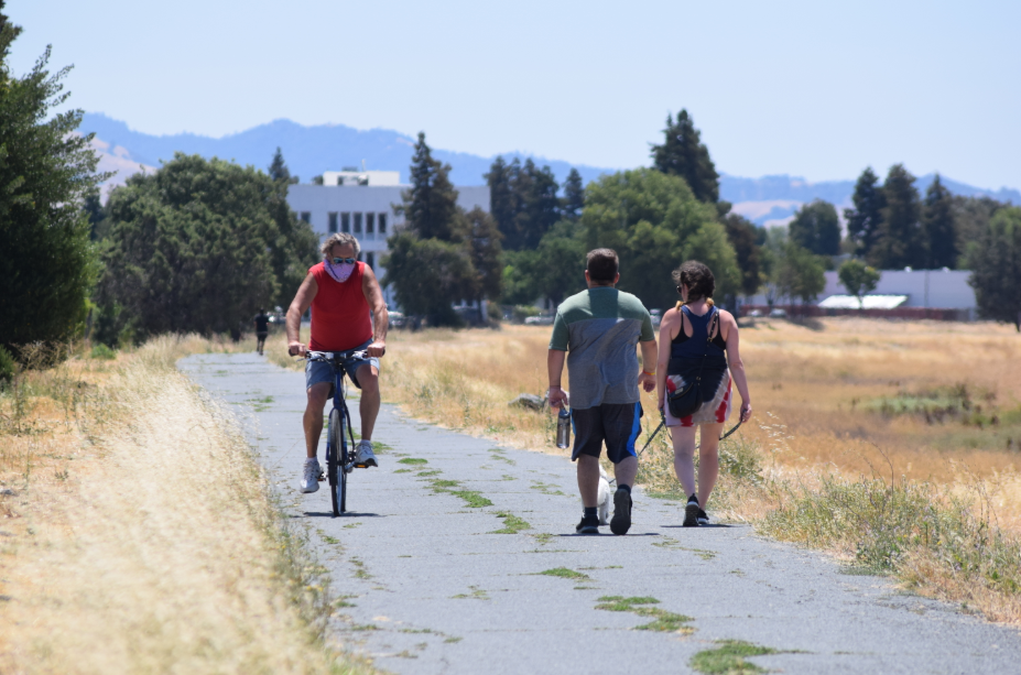
A study of how the Iron Horse Regional Trail in central Contra Costa County can better host more efficient long-distance bicycle commuting, and still safely cater to slower-moving walkers and joggers, has been praised by the county Board of Supervisors for promoting both transit and recreational uses.
The Iron Horse Corridor Active Transportation Study, accepted by the county supervisors last week, lays out some ways the trail can be more commuter-friendly.
Among the proposals are separating the faster bicycle traffic from slower walkers and joggers to make the trail safer for all users; improving trail access to BART stations and other area trails; possible installation of overpasses at some higher-traffic street intersections now guarded by traffic signals; improving trail lighting, and, in general, “reduce user conflicts.”
Jamar Stamps, a principal planner with the county’s Department of Conservation and Development, told the supervisors that specific projects haven’t yet been designed. But he said the plan is for the trail to be split
into approximately 15 “design segments,” with two or three suggested projects on each segment.
Supervisor Candace Andersen of Danville said it will ultimately be up to the cities through which the trail runs, perhaps in partnership with other agencies, to evaluate, design and find money for each project.
The Iron Horse Regional Trail stretches about 30 miles, starting at Marsh Drive just south of state Highway 4 in Concord and running through Pleasant Hill, Walnut Creek, Alamo, Danville and San Ramon to the Alameda County line, and a few miles further south into Dublin and Pleasanton.
Most of the trail south of Monument Boulevard in Concord is on a former Southern Pacific rail line that hosted trains from 1891 until 1977.
The first trail segments on this corridor opened in 1986.
Though there have been discussions at various times since then about possible conversion of parts of the trail into a rail or bus transit route, none of that came to fruition. Andersen said last week that such plans weren’t feasible economically, and have been overwhelmingly unpopular with people living near the trail.
The 2019 passage of Assembly Bill 1025, which essentially relinquished the right to turn the trail route into a mass-transit corridor, has ensured rails can’t return to the trail.
There will be “no restoring it back to the days of the Southern Pacific,” Andersen said.
Instead, the goal of this study is to determine whether the trail can practically be improved for better “active transportation” uses, including commuter bicycling, as well as e-bikes and e-scooters.
Stamps said, though, that the use of “shared autonomous vehicles” might one day be practical on trail segments near job centers in San Ramon (mainly the Bishop Ranch business park) and Walnut Creek. That, he said, would require some specific trail modifications.
Planning for this report has been underway for almost two years.
Public opinion had been gathered at several Bike to Work Day stations and other “in-person engagement events,” and from January through August 2019 via a web-based mapping tool, through which more than 400 comments about trail uses were registered. Presentations have been hosted by the Danville Town Council and the Alamo Municipal Advisory Council.
Last week, David Schonbrunn, president of the Train Riders Association of California, told the supervisors that, with AB 1025, they had blown a chance to make at least the San Ramon section of the Iron Horse Trail into part of a planned Tri-Valley San Joaquin Regional Rail Authority “Valley Link” commuter rail route connecting Lathrop and Dublin-Pleasanton BART.
“Your board caved in to the NIMBYs and their short-term thinking,” Schonbrunn said.
That isn’t how Andersen sees it.
“We want (the trail) to keep its wonderful charm, but at the same time utilize its ability for people to go up and down the trail without running into one another, and to get to and from work or school,” she said.
photo credit: Sam Richards
I am not happy about Automous vehicles sharing the Iron Horse Trail! That is sad. The trail is nice to get away from cars!
Do not attach bart to the trail.
Get Elon Musk to tunnel under the existing trail it and give us a hyper loop from Martinez to San Jose and last mile autonomous Pick/up drop off locations
The trail could be widened on one side to include designated areas for battery powered bikes and scooters. I would want barriers to keep everyone safe
Why don’t they wait until the covid issues have passed…. With people working from home, may not be a need to mess this trial up by adding commuter access.
In retrospect they probably should have kept it rail for light rail transit.
A couple years back, I was on the IHT behind WCI. That little robot delivery box zoomed by me. So sad I didn’t get a picture. Never saw it again.
Lobbyists like David Schonbrunn use the term NIMBY to personally attack people, and bully people. The term NIMBY is so overused, and is so meaningless that it can be applied to anyone a person doesn’t agree with.
Bishop Ranch already has buses that travel direct to BART stations. There are also gas lines and power lines along the Iron Horse in San Ramon, as well as a creek. I doubt very much that Schonbrun has spent much time on that part of the trail. He’s probably only thought about the land abstractly on his computer.
There shouldn’t be buses or trains or autonomous-cars on the Iron Horse. It is a hiking and biking trail, and for some people it’s for horses too. The trail is an outdoor recreational space for many people, or a place to go bird watching. It shouldn’t be a bustling transit corridor.
I use the Iron Horse daily to commute by bike. So it is a transit corridor. There are far better and safer places to go bird watching.
Commuter – It isn’t a transit corridor as the term is defined, as it is not a route for public mass transit. It’s as simple as that.The Iron Horse is not a transit corridor.
The Iron Horse is managed by the EBRPD, not by Cal Trans. It is not a transit corridor. It is a linear park. Just because people use the park to get from point A to point B doesn’t negate the fact that it is a trail park.
People have every right to enjoy the nature they see on the Iron Horse. For many people, the Iron Horse is the closet park to where they live. There is no minimum speed limit, and no rule against stopping to look at stuff. Like or it not, most people use the trail for recreation and relaxation. There is a lot of nature on the Iron Horse. Bicyclists have to keep in mind that is not a race track. I am a bicyclist myself. The Iron Horse actually is a very good spot to do bird watching, or to look at trees and other aspects of nature.
@commuter It is NOT a transit corridor, just because YOU use it as one.
“I use the Iron Horse daily to commute by bike. So it is a transit corridor.“
Commuter’s truth.
This corridor was purchased with transportation funds and was supposed to eventually have a light rail line. Imagine how nice it would be to have a straight shot from Concord or Pleasant Hill to San Jose. But alas, the Bike Nazis have made that impossible.
No you don’t get to turn the Iron Horse Trail into a light rail or commuter highway! We love our neighborhood without crazy vehicles zooming around to BART. The cyclists are not the ones in charge. The residents are.
That’s Sacramento Northern, not Southern Pacific.
SP actually ran on that line to the quarries in Pleasanton/Livermore.
https://www.abandonedrails.com/san-ramon-valley-branch
Michael Churma:
Thank you for that information.
I do believe you’re right.
The Sacramento Northern came east along Olympic Blvd. and turned north along California – that’s why the Genova Delicatessen and the CVS are at such a weird angle to the streets. Then it went north and the old right of way is now the BART tracks. The SP was a little further east and is now the bypass creek and the Iron Horse Trail. The two crossed at Las Juntas and the Iron Horse Trail.
Again, thank you for this link – I retract my comment!
straight shot from Concord to San Jose is called 680
Leave it completely alone, sometimes less is more. Don’t paint lanes on it either, leave as close to getting away from civilization as possible. Its the best park in the east bay.
As a regular user of the trail, I hate riding the Concord part. It is in total disrepair.
Joe
I notice that on the surface streets as well. WC and P.Hill have beautiful restoration of asphalt. The repairs on Concord streets are so bad! Where do our tax dollars go???
We need a link up to the Delta-De Anza Trail. Willow Pass is a death zone for bikers with the new lane dividers on the bridge.
I hope the study will include a real plan on cleaning up the trash and homeless encampments that are out of control.