The Claycord Online Museum – Every Tuesday at 2pm on Claycord.com.
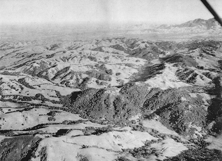
Thanks to “Ancient Mariner” for this picture of Mt. Diablo (top right) and the surround hills. It was taken in the 50s or early 60s, according to “Ancient Mariner”.
What a beautiful view. Can anybody guess where this photo was taken?
ABOUT THE CLAYCORD ONLINE MUSEUM: The Claycord Online Museum is made up of historical photos, documents & anything else that has to do with the history of our area.
If you have any old photos or items that you’d like to place in the Claycord Online Museum, just scan or take a photo of them, and send them to the following address: news@claycord.com. It doesn’t matter what it is, even if it’s just an old photo of your house, a scan of an old advertisement or an artifact that you’d like us to see, send it in and we’ll put it online!
Click on the tag below titled “Claycord Online Museum” to view other items!


>Can anybody guess where this photo was taken?
I guess Brentwood.
I don’t remember Brentwood being that hilly. 🙂
That’s a lot of miles of beautiful. It reminds me of when my mom joined the “Marsh Creak Country Club” in @1958. The rates were a real bargain. She drove us out from our El Cerrito apartment for what seemed like hours (Are we there yet?) and hours (Are we there yet?) for a picnic and a swim out dead in the middle of nowhere.
My folks also were members, remember going out to swim with my sisters an vaguely remember dinning room and creek.
@Silva
That sounds totally awesome.
You were living my dream childhood.
You know you could have stopped
in Pleasant Hill and picked me up.
It was a miracle the old Hudson made it both ways every time, though we often had just got it back from the mechanic..
Picture Maybe taken from an airplane flying North from South looking at the Diablo Valley with Mt. Diablo to the Northeast.
Looks like photo was taken up by Briones or Port Costa……. from an airplane.
It looks to me like a view of Mt. Diablo in the distance, from a plane (a strut can be seen in the upper right corner) flying low over the Oakland/San Leandro hills in the foreground.
The photo looks like it was taken while flying above what is now the land between Briones Reservoir and San Pablo Reservoir, and pointed looking almost due east. Mount Diablo is in the background, Walnut Creek and Pleasant Hill now cover the flat areas in the left/center background of the photo, and the two valleys in the middle of the photo are now filled with the water of Briones Reservoir. That dates the photo to before the mid 1960s. San Pablo Reservoir may have been just below the plane, out of view of the camera.
Marsh Creek Country Club. Did it include a golf course?. I used to play Royal Oaks on Marsh Creek years ago until it shut down. (Could have bought it for $1.25 million)
I don’t remember if there was a golf course. Could’ve been I suppose. There were two pools and trail horses for certain. It was rustic and lovely, and unlike any other country club I’ve ever seen. No swank.
Thanks for posting this, Mr. Mayor!
I’d forgotten all about it.
Nice picture, Ancient Mariner! Were you piloting the plane?
My first take was that it was snow on the foreground hills, so I was guessing it was taken from the Sierra Nevada foothills….. but now that I look at :Mount Diablo’s taller North Peak being so far to the right, almost anyone else’s guess makes more sense than mine!
Gotta agree with Karl. It looks like where they put the Briones Reservoir in 1964.
Agree with you, Dr. Jelly and Karl. That was my first thought: above Briones.
And taken from the rear seat, pilot side of a high-wing airplane.
My best guess is Karl also.
Yes, Karl’s correct.
No, Antler, I wasn’t flying the plane that day!